
Ramsey to St Ives:
Ramsey to Warboys
The first two walks on the Trail from Ramsey to St Ives:
1 (9) Ramsey to Wistow via Bury – published
2 (10) Wistow to Warboys via Broughton – published
Walk guides can be downloaded below
or from The Walks page.

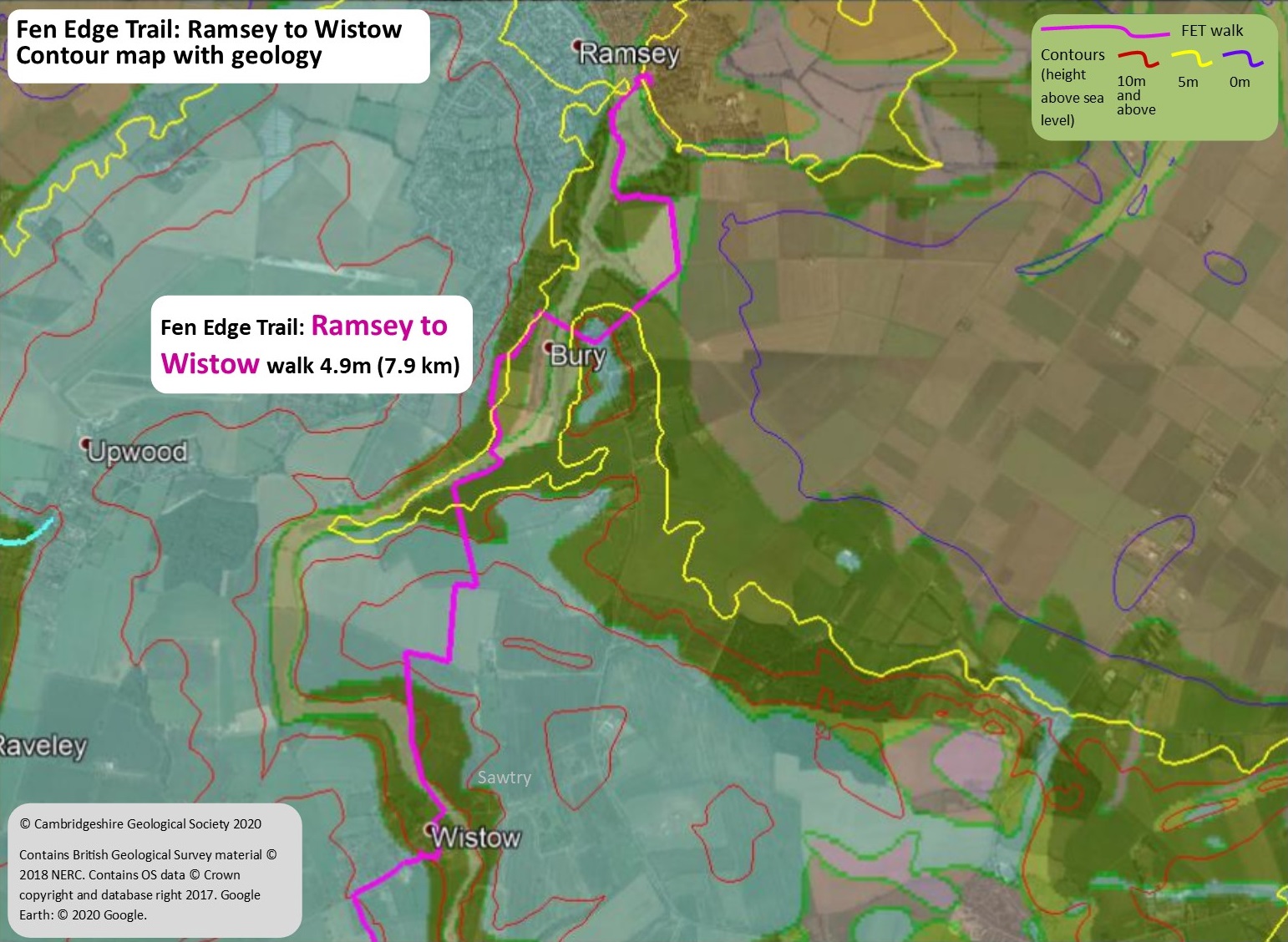
Walk 1 (9): Ramsey to Wistow
DOWNLOAD WALK GUIDE


‘My favourite area on this walk is at the start – the Church Green and Abbey Green – it’s an attractive place to be on a sunny summer’s day.’
The route: ‘follow the ancient brook’
4.9 miles (7.9 km) Walking guide time 2hrs 20mins plus stops
In partnership with ![]()
Having travelled across from Sawtry in the west, the Fen Edge Trail turns south to link the historically important town of Ramsey and the picturesque, riverside town of St Ives. This walk, from Ramsey to the village of Wistow is the first part of this journey. Optionally, you can begin by exploring Ramsey itself, following one of the walks through the town (www.discoverramsey.co.uk).
A significant religious centre developed on the remote ’island’ that extends out into the fen. The location of the town was fundamental to its growth, being on the edge of a peninsula of higher land in a strategic position between the extensive wetlands to the north, east and west, and more hospitable, dryer land to the south. Ramsey Mere, to the north east, was a rich source of food and other resources, and the town’s value increased when it became a fen edge port connected to the River Nene. Starting at the Ramsey Abbey Gatehouse, the walk follows Bury Brook, a tributary of the old Nene, before crossing low lying fenland to reach Bury and the brook again. Passing over low hills, it finishes in Wistow, further up the valley, with the next walk continuing up to Broughton before going on to Warboys.


Landscape and Geology
In this area there are four general types of ‘rock’ currently at the surface. The oldest is the Oxford Clay, which is about 160 million years old (from the Jurassic Period, famous for its dinosaurs). An extensive sea covered this part of Britain at the time and the clay formed from material on the sea floor – it is famous for the fossils of huge marine reptiles such as Pliosaurs and Ichthyosaurs. There is also a small area of Ampthill Clay (Jurassic but younger than Oxford Clay). The other surface ‘rocks’ are much younger, all being from the current ‘Ice Age’ which started 2.6 million years ago. The first are glacial, river and slope deposits (including gravels and finer ‘till’) from the Pleistocene epoch (which ended 11.7 thousand years ago), the second are river deposits (Alluvium) left during the Holocene epoch (the last 11.7 thousand years) and, finally, there is Peat, which formed in the last few thousand years in the fenland basin.
Geology map from Maps leaflet


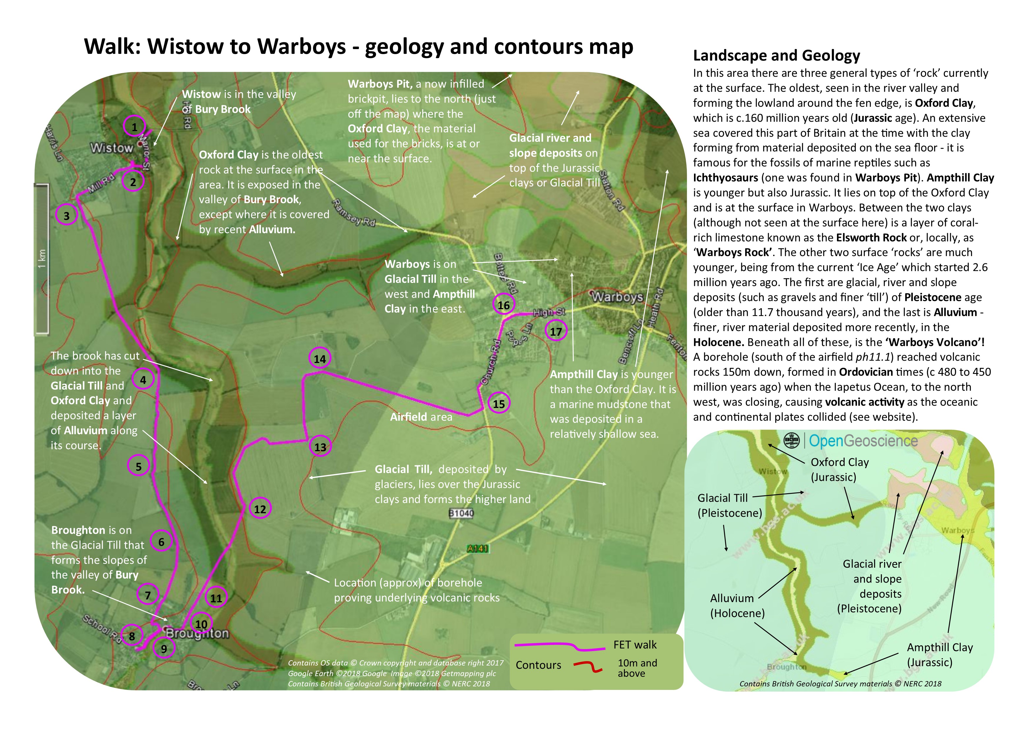
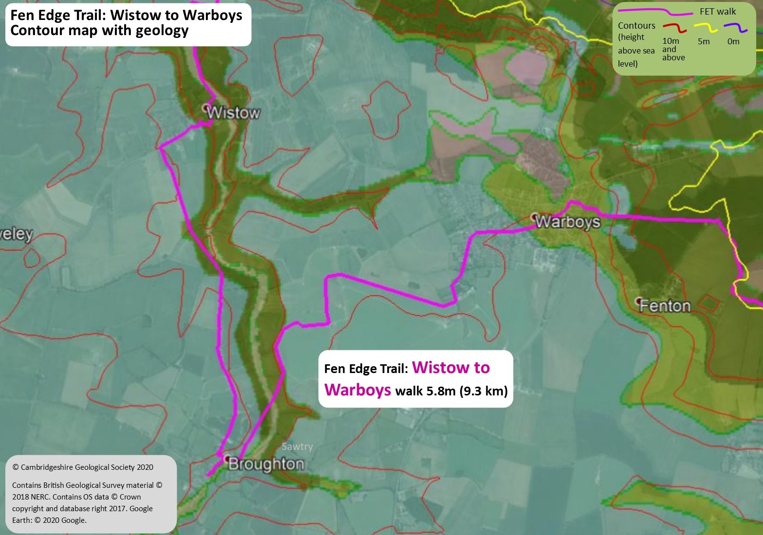
Walk 2 (10): Wistow to Warboys
DOWNLOAD WALK GUIDE


‘You are never more than a quarter of a mile from a volcano on this walk (its beneath you!).’
The route: ‘high hills, distant skies and deep time’
5.8 miles (9.3 km) Walking guide time 3hrs plus stops
In partnership with ![]()
This walk, on the south western Fen Edge, is the second stage of the Trail linking Ramsey and St Ives. Having arrived in Wistow from Ramsey via the valley of the of Bury Brook, the route continues to climb up the valley leaving it at the village of Broughton to head east, passing over higher land to the larger village of Warboys. Starting at about 11 metres a.s.l. at the bridge over the brook in Wistow, the walk reaches the ‘heady heights’ of 30 metres a.s.l. as it approaches Warboys and passes one of the famous RAF Pathfinder airfields whilst following the Pathfinder Way for the second half of the journey. In this area you are also near the site of the ‘Warboys borehole’ where samples of rock obtained from depths of about 150 metres (below sea level) were found to be part of the extensive volcanic complex (long extinct!) that underlies this part of Cambridgeshire. The walk finishes at the Public Library in Warboys, a significant village once famous for its brickmaking, that stands on the higher land on the edge of the fen, in an area of historic importance as a crossroads.


Landscape and Geology
In this area there are three general types of ‘rock’ currently at the surface. The oldest, seen in the river valley and forming the lowland around the fen edge, is Oxford Clay, which is c.160 million years old (Jurassic age). An extensive sea covered this part of Britain at the time with the clay forming from material deposited on the sea floor – it is famous for the fossils of marine reptiles such as Ichthyosaurs (one was found in Warboys Pit). Ampthill Clay is younger but also Jurassic. It lies on top of the Oxford Clay and is at the surface in Warboys. Between the two clays (although not seen at the surface here) is a layer of coral-rich limestone known as the Elsworth Rock or, locally, as ‘Warboys Rock’. The other two surface ‘rocks’ are much younger, being from the current ‘Ice Age’ which started 2.6 million years ago. The first are glacial, river and slope deposits (such as gravels and finer ‘till’) of Pleistocene age (older than 11.7 thousand years), and the last is Alluvium – finer, river material deposited more recently, in the Holocene. Beneath all of these, is the ‘Warboys Volcano’! A borehole (south of the airfield) reached volcanic rocks 150m down, formed in Ordovician times (c 480 to 450 million years ago) when the Iapetus Ocean, to the north west, was closing, causing volcanic activity as the oceanic and continental plates collided.

Geology map from Maps leaflet


Fen Edge Trail Partners: Warboys Archaeology Group
Warboys Archaeology Group (WAG) began in 2012 as a sub-group of Warboys Local History Society but it is now an independent organisation. It has undertaken several excavations locally. Among its many excavations, discoveries of note are:
– The floor and part of the walls of a small building under the lawn of the Manor House (c.1620), next to the parish church. The building appeared to have been associated with a light industrial activity, possibly processing fish and eels, in the late 17th C.
– A small banjo-shaped enclosure, dating to the late Iron Age/early Roman period, near RAF Wyton. A banjo enclosure is a banjo-shaped ditch with low earthworks and a fence or hedge used to corral animals overnight and often containing a roundhouse.
– Late Iron Age/early Roman ditches close to the Fen Edge Trail between Warboys and Pidley.
– A medieval moated enclosure near Pidley.
– In 2019, WAG assisted Oxford Archaeology East in the excavation of an important Late-Iron Age to Early-Saxon settlement on the edge of Warboys. The earliest finds include 8 roundhouses, some of which date back to c. 100BC, three crouched human burials and 2,500-year-old pottery remains. The 10-acre site provided evidence of Roman rural industry, including a 15ft corn dryer and kilns. Archaeologists uncovered human cremations and 6 burials. They also “seem to have stumbled upon a shrine” and discovered cattle skulls and a largely intact horse skeleton, which they believe could be votive offerings. The settlement reverted to agricultural use after the 7th Century.
WAG received a National Lottery grant for a 3-year investigation of the site of the 10th century Ramsey Abbey. It has completed an extensive geophysics survey and has arranged and assisted with annual community excavations run by the professional group Oxford Archaeology East. The group also assists other amateur and professional groups on their excavations.
![]()
© Cambridgeshire Geological Society