
The sea in the Fens!
Salt marshes, silts and sand
The Cambridgeshire Fens are known for their peat but large areas, particularly in the north (as in Lincolnshire) are covered, not by peat but, by silts and clays that were deposited when the sea inundated the land when sea levels were higher. Rather than open water, most of the fens were covered by salt marshes, similar to those on the North Norfolk Coast today. The muds that built up to form the marshes were compressed to make the clays that now cover extensive areas, intermingled with silts (larger ‘grains’ than clays).
There have been several periods of minor sea level change since the end of the last glaciation but two in particular were large enough to affect significant areas of the low-lying Fen basin.
The first occurred at the end of the Neolithic Period, sometime after 4700 years ago (BP), and lasted into the Bronze Age, leaving the ‘tidal-flat’ deposits of the Barroway Drove Beds. This, the most extensive incursion, brought marine conditions inland almost as far as the current 5 metre contour (5m above current sea level), although different parts of the fenland were affected at different times and there was at least one major retreat of the sea during it, when freshwater conditions existed for long enough for the development of peat in some areas.
The second occurred in Romano/British times, c 2050 years ago (BP), leaving the deposits of the Terrington Beds, mostly in the north of the county. The peat that formed in the freshwater conditions between the two main periods of marine incursion still remains in many areas although much has been eroded, as has most of the Peat that developed in the last couple of thousand years since the last one.

Roddons north of Littleport
")
Undulating land formed by roddons at the Great Fen (Stokes Farm)
The remains of the tidal marshes
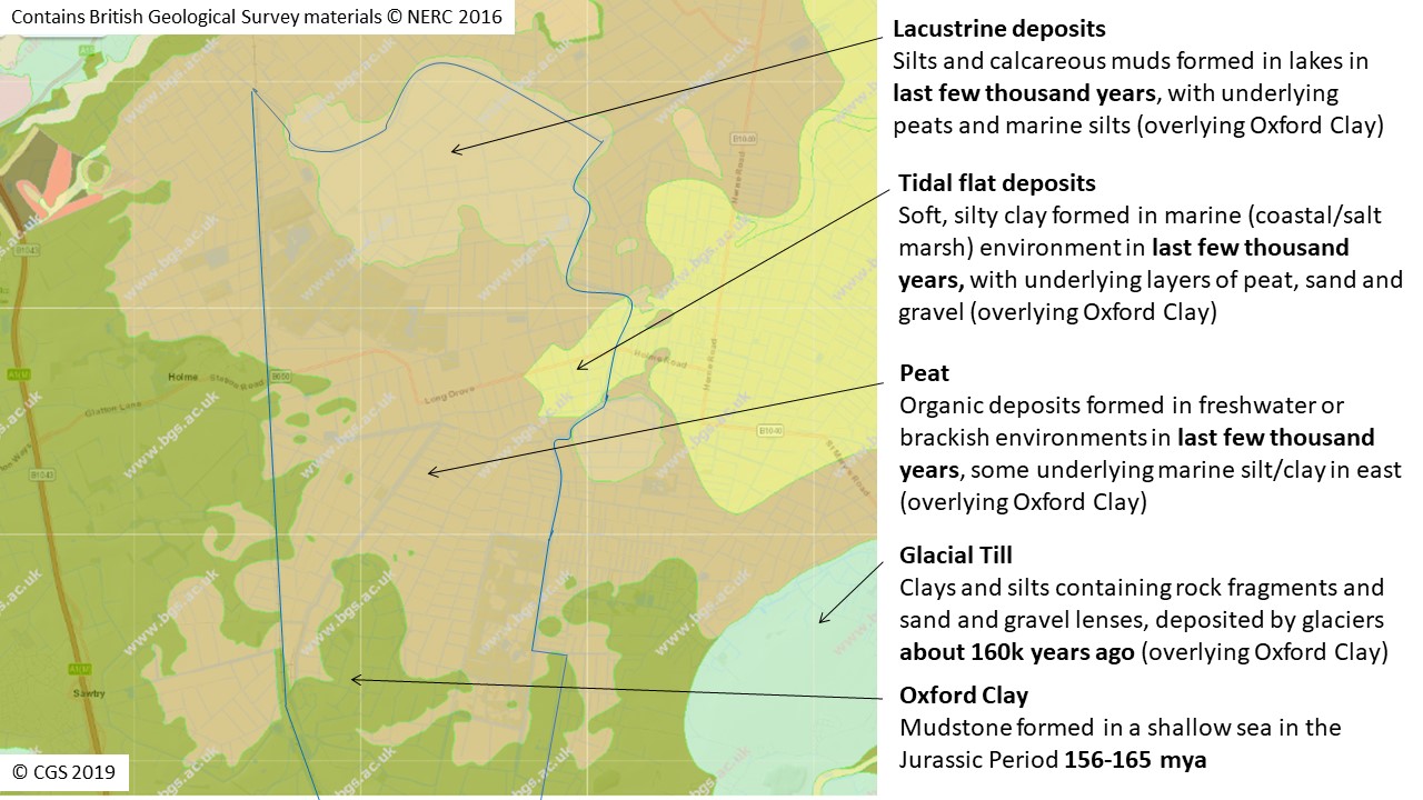
Over much of the Cambridgeshire fenland, the ground surface today is not covered with (freshwater) Peat but with the silts and clays that are the remains of the tidal salt-marshes that date from the Neolithic/Bronze Age marine ‘flooding’. These reach quite a way south and west, for example, to near Ramsey, near Chatteris and past Doddington. These marine deposits also underly much of the Peat in other areas. They are also present at the surface in the east of the newly designated Great Fen Local Geological Site that covers Holme Fen and Whittlesea Mere. The geology map shows them (yellow) in the Great Fen area (red outline). Ramsey is in the bottom right corner and Yaxley in the top left.
The geology of the Holme Fen and Whittlesea Mere Local Geological Site in the Great Fen
Roddons
The tidal creeks of salt marshes formed a complex ‘dendritic’ drainage pattern and at some stage were infilled by silt and sand brought up from further out on the coast. Research has shown that this infill happened relatively quickly, presumably due to a fairly rapid change in sea level. These silts and sands suffered less from the subsequent drainage of the land and now stand higher than the surrounding clays and silts forming ‘fossilised channels‘ that can be seen today. The larger ones are obvious on aerial photographs and even many of the smaller ones can be seen as ridges in fenland fields. Current watercourses sometimes cut across these older channels and their outline can be seen on the former’s banks. The dating of the material in the roddons has revealed the complexity of changing conditions, between marine and freshwater, and their pattern has shown significant changes in the direction of water flow between the periods when the channels were active.
More information (from a University of Cambridge field trip): River and water management in the fenland
")
Roddons at Plash Drove, Wisbech St Mary (photo Dinah Smith)

Roddons near Thorney
Dr Dinah Smith studied the fenland roddons for her PhD at University of Leicester. Here, she describes their formation:
‘Fenland roddons, sometimes spelt rodhams, roddams or roddens are fossilised sand and silt filled tidal creek systems of mid to late Holocene age (6000-2000yr BP), incised into contemporaneous clay deposits. The architecture of the roddons generations (of which three have been identified) and the pattern of their infill appear to have been affected by the palaeogeography of The Wash and number of sea incursions after the Ice Age.
Roddons vary in channel width from ca. 2m to >1km and in depth from 1m to >10m. The largest roddons are called trunk roddons (250-1000m) and are filled with fine sands and the smaller tributary roddons are referred to as “major” or “minor”. These contain more silts than sands and the minor roddons may have a small clay/ mud content.
Sedimentation in the roddon channels was dominated by the influence of these marine conditions as indicated by the (fossilised) foraminifera and ostracods although in some areas a salt marsh community was established. Roddons differ from the tidal creeks in The Wash area and although they show well developed dendritic meandering patterns there is little or no evidence of sand or silt infill during active meandering and this suggest rapid infill.
The sand and silt infill formed ridges (roddons) after the surrounding landscape was subjected to preferential subsidence and erosion due to anthropogenic drainage. The roddons are visible in the landscape as subtle ridges up to 1m high.’
This lidar image clearly shows the snake-like patterns of the roddons near Thorney with a large channel shown to the east fed by numerous smaller channels. These patterns are less easily seen on the ground although the colour of the soil on them is lighter than the surrounding land and they form low ridges, which are sometimes very obvious. Image by Richard Cushing, LIdar data from Environment Agency.
")
Examples can be seen between Whittlesey (NGR TL 270973) to Ramsay St.Mary (TL 256880). Several examples and images are to be found in ‘The Black Fens‘ by A K Astbury (1958, The Golden Head Press Ltd. Cambridge).
See ‘Holocene drainage systems of the English Fenland: roddons and their environmental significance‘ and ‘The anatomy of a Fenland roddon: sedimentation and environmental change in a lowland Holocene tidal creek environment‘.
© Cambridgeshire Geological Society