
Eight walks
1 (32) Ely to Little Downham
2 (33) Little Downham to Witcham via Coveney
Being developed
3 (34) Witcham to Sutton – published
4 (35) Sutton to Haddenham – published
5 (36) Haddenham to Wilburton – published
6 (37) Wilburton to Stretham – published
Download Walk Guides below
7 (38) Stretham to Ely via Little Thetford – due 2026
8 (39) Prickwillow to Littleport
Being planned

Compared to the cultural richness of Cambridge, the fenland lying to the north of the city may, initially, seem ’empty’ but its story is one of dynamic landscape changes and considerable historical interest. Both literally and culturally, the highpoint of the area is Ely Cathedral which can be seen for many miles around due to its elevated position (at an elevation of c 20 metres!) on the ‘Isle of Ely’, now surrounded by low lying land some of which is below sea level.
The isle also has geological riches including the building stones of the cathedral itself, a good quality limestone from Barnack quarry in the far north west of the county, and the nationally important site Ely Pits and Meadows SSSI, designated for its Jurassic marine reptile fossils and also for its biological importance as a site for breeding birds. Other significant discoveries have also been made in the area including ‘Kevan, the Stretham pliosaur‘. This important find was dug from the Kimmeridge Clay, a Jurassic rock famous for its fossils, that is seen at the surface in various parts of south east Cambridgeshire as well as at its more well-known outcrop on the Dorset coast. Some of the remains of ‘Kevan’ were preserved at the Sedgwick Museum of Earth Science in Cambridge and one of the hind paddles, over 2m long, is still on display there.
Each walk guide has a summary of the local geology. There is more information on the CGS website. For detailed information on the geology of the Ely District see the British Geological Survey website.


")


Walk 1 (32): Ely to Little Downham
being developed
This walk, the first on the Isle of Ely, links the city with the villages of Chettisham and Little Downham. After heading downhill towards the River Great Ouse, that flows along the east side of the city centre, it follows the river north before heading west through low pastures to Chettisham. From here, it crosses the A10 to reach the slightly higher land on which Little Downham sits.

Walk 2 (33): Little Downham to Witcham
via Coveney
being developed
From Little Downham, this walk crosses the low, northwest facing ‘mouth’ of the bay through which Grunty Fen Drain flows on its way to the New Bedford (100 foot) River at Oxlode. It then passes through the village of Coveney before skirting Wardy Hill and heading uphill into Witcham.


Walk 3 (34): Witcham to Sutton
DOWNLOAD WALK GUIDE
‘Fascinating – three ancient villages on the water’s edge, one in a bay, one on a headland, one on a steep ridge’
The route: ‘on the edge – between the Isle of Ely and the wild fens’
6.3 miles (10.1 km) Walking guide time 3 hours minimum plus stops
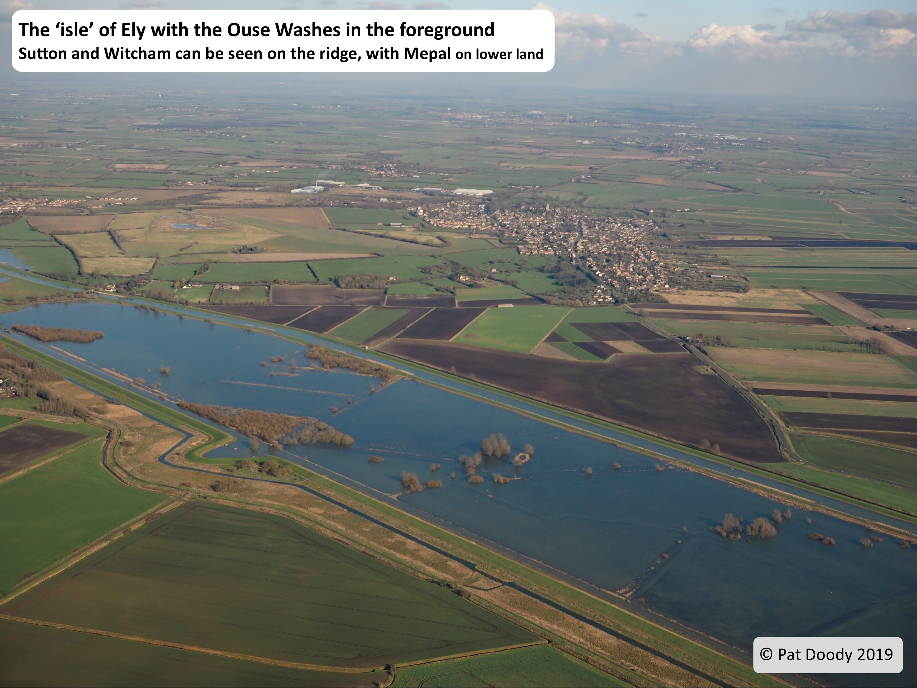
This walk, on the northwest edge of the Isle of Ely, links the three villages of Witcham, Mepal and Sutton. The high ground forming the Isle, reaching some 86 feet (26 metres) above sea level, consists of Jurassic clays overlain in part (although not in this area) by Cretaceous Lower Greensand. This bedrock is capped with Glacial Till and Glacial River material. The Isle of Ely is better thought of as the ‘Ely archipelago’ since it includes such separate ‘isles’ as Littleport, Coveney and Wardy Hill. Prior to the draining of the fens in the 17th century the Isle was surrounded by freshwater marshes and meres. This walk follows ancient droves and ‘ways’ around the edge of the ‘island’ linking the historic villages that sit on key promontories where once our ancestors sat and looked out across the extensive marshes (a sea during Neolithic times!). We start in a ‘bay’ where Witcham sits; we then rise over one of several headlands to drop down into the fen via a 2000 year old road. By following the old Catchwater and crossing a section of fen we arrive at the village of Mepal – once the jumping off point to the island of Chatteris. From Mepal our way follows the great works of the 17th century drainage engineer Cornelius Vermuyden, as we walk a section of the raised banks of the ‘New’ Bedford Level. At Sutton Gault we start walking up off the fen to arrive at a ‘headland’ that rises steeply back up onto the Isle at the village of Sutton.


Landscape and Geology
In this area there are two ‘bedrocks’ at the surface. The oldest, underlying the lower land in this part of the fens, is Ampthill Clay, which is c.155 million years old (Jurassic age). An extensive sea covered this part of Britain with the clay forming from material deposited on the sea floor. The Kimmeridge Clay is younger (also Jurassic) and lies on top of the Ampthill Clay forming a series of roughly east-west ridges. It is famous for the fossils of marine reptiles such as Plesiosaurs. The other surface ‘rocks’ are much younger, from the current ‘Ice Age’ (starting 2.6 million years ago). The oldest is Glacial Till left by retreating glaciers, and Glacial River Sands and Gravels which remain on the hill tops. These are both of Pleistocene age – deposited during the Totternhill Glaciation, 160,000 years ago when a tongue of ice extended south over the fens. In the Holocene (the last 11.7 thousand years, since the Devensian Glaciation), the Ouse has deposited River Terrace Sands and Gravels, some remaining northeast of Witcham and in Mepal Fen, west of the Washes. A small patch of marine Shell Marl in Mepal Fen shows the sea once reached here (in the Neolithic). Peat formed from decaying vegetation in freshwater ’swamps’, whilst Alluvium is fine, river material, that is still deposited when the river floods.


One of our Fen Edge Trail team, Paul ‘The Fenland Coddiwompler’, has created a series of videos showing his journey along the Fen Edge Trail, including this walk:
(CGS/The Fen Edge Trail has no right to or ownership of this video content.)
Walk 4 (35): Sutton to Haddenham
DOWNLOAD WALK GUIDE
The Permissive path taking you up North Hill may not be possible at the moment. Please check with us before doing this walk as we are trying to check the situation.
‘The fabulous views from the top of North Hill are a real surprise‘
The route: ‘along the Catchwater and over the high hills on the Isle of Ely‘
5.3 miles (8.5 km) Walking guide time 3 hours minimum plus stops
This part of the Fen Edge Trail links the two villages of Sutton and Haddenham, which lie in the south west of the Isle of Ely. The Isle is better thought of as an archipelago, since it includes such separate ‘isles’ as Littleport, Coveney and Wardy Hill. Prior to the major draining of the Fens in the 17th century, the Isle was surrounded by freshwater marshes and meres. This walk follows ancient droves and ways, alongside the Catchwater Drain, around the edge of the Isle linking these historic villages that sit on key promontories where, once, our ancestors sat and looked out across marshes or, sometimes, even sea. We start on the higher slopes of the Sutton ridge, on which the church stands, but drop rapidly down to the low fen, reaching just 2 metres above sea level. After skirting the drained ‘bay’ between Sutton and Haddenham, walking for some time along the 5m contour (the classic ‘fen edge’), we then climb once more onto a ‘headland’ and pass the highest point on the Isle, North Hill, with its stunning views in all directions. Descending from the hill, we walk a section of the ancient route between Earith in the west and Ely in the east by following Hill Row as it climbs to higher ground at the centre of the village of Haddenham, once a major crossroads in the Fens. The high ground that creates the Isle is formed by a series of ridges made from Jurassic and Cretaceous bedrock, including the famous Woburn Sands (better known from Bedfordshire), capped in places by glacial material and reaching a height of some 40 metres (133 feet) above sea level.


Walk 5 (36): Haddenham to Wilburton via Aldreth
DOWNLOAD WALK GUIDE
‘We crossed seven different types of geology in just over two and a half miles! That doesn’t happen often on The Fens‘
The route: ‘on the Isle of Ely: from the high ridge, along the ancient causeway to the river‘
6.4 miles (10.3 km) Walking guide time 3 hours plus stops
This part of the Fen Edge Trail links the three villages of Haddenham, Aldreth and Wilburton which lie on the south west edge of the Isle of Ely. The high ground forming the Isle of Ely sits on a series of ridges formed by Jurassic and Cretaceous bedrock, including the famous Woburn Sands known better for being from Bedfordshire. The ridges are capped, in places, by Glacial Deposits reaching the height of some 40 metres (133 feet) above sea level. The Isle of Ely is better thought of as an archipelago since it includes such separate ‘isles’ as Littleport, Coveney and Wardy Hill. Prior to the major draining of the fens in the 17th century the Isle was surrounded by freshwater marshes and meres. This walk follows ancient droves and ways around the edge of the ‘island’ linking the historic villages that sit on key crossroads, ridges and promontories where once our ancestors sat and looked out across marshes or, sometimes, even sea. Starting on the high ground at The Green on the crossroads in Haddenham, the walk heads south on a ridge leading to the hamlet of Aldreth, where it drops down to the lower fen. From here, it follows the historically important Aldreth Causeway down to the Old West River (part of the River Great Ouse), on the edge of the drained ‘bay’ that extends west out towards the Ouse Washes. Returning to the higher land, the route then climbs up to finish in the village of Wilburton, which sits further east on the main ridge that runs across the southern part of the Isle. The walk includes excellent views, particularly to the west and south from the Isle towards Cambridge. A shorter option can be chosen, omitting the walk from Aldreth down to the river and back.
This part of the Fen Edge Trail links the three villages of Haddenham, Aldreth and Wilburton which lie on the south west edge of the Isle of Ely. The high ground forming the Isle of Ely sits on a series of ridges formed by Jurassic and Cretaceous bedrock, including the famous Woburn Sands known better for being from Bedfordshire. The ridges are capped, in places, by Glacial Deposits reaching the height of some 40 metres (133 feet) above sea level. The Isle of Ely is better thought of as an archipelago since it includes such separate ‘isles’ as Littleport, Coveney and Wardy Hill. Prior to the major draining of the fens in the 17th century the Isle was surrounded by freshwater marshes and meres. This walk follows ancient droves and ways around the edge of the ‘island’ linking the historic villages that sit on key crossroads, ridges and promontories where once our ancestors sat and looked out across marshes or, sometimes, even sea. Starting on the high ground at The Green on the crossroads in Haddenham, the walk heads south on a ridge leading to the hamlet of Aldreth, where it drops down to the lower fen. From here, it follows the historically important Aldreth Causeway down to the Old West River (part of the River Great Ouse), on the edge of the drained ‘bay’ that extends west out towards the Ouse Washes. Returning to the higher land, the route then climbs up to finish in the village of Wilburton, which sits further east on the main ridge that runs across the southern part of the Isle. The walk includes excellent views, particularly to the west and south from the Isle towards Cambridge. A shorter option can be chosen, omitting the walk from Aldreth down to the river and back.


‘Grunty Fen and the Stretham Old Engine – this area is so interesting’
The route: ‘Along the edge of the ‘bay’ of Grunty Fen down to the iconic old pumping engine on the river’
3.6 miles (5.8 km) or 6.3 miles (10.1 km) including Stretham Old Engine
This walk is part of the Fen Edge Trail around the Isle of Ely. It links the villages of Wilburton and Stretham, which lie on the southern edge of the Isle, along a ridge of Jurassic and Cretaceous bedrock that reaches a maximum height of some 40m (133 feet) above sea level (on the western end near Haddenham). The bedrock includes the famous Woburn Sands, known for underlying the ‘Greensand Ridge’ in the south west of the county and also for forming the hill on which Ely Cathedral sits. The ridges of the Isle are capped, in places, by Glacial deposits, mostly ‘Till’, which adds to their height.
This walk is part of the Fen Edge Trail around the Isle of Ely. It links the villages of Wilburton and Stretham, which lie on the southern edge of the Isle, along a ridge of Jurassic and Cretaceous bedrock that reaches a maximum height of some 40m (133 feet) above sea level (on the western end near Haddenham). The bedrock includes the famous Woburn Sands, known for underlying the ‘Greensand Ridge’ in the south west of the county and also for forming the hill on which Ely Cathedral sits. The ridges of the Isle are capped, in places, by Glacial deposits, mostly ‘Till’, which adds to their height.


Prior to the major draining of the fens in the 17th century, the Isle was surrounded by freshwater marshes and meres and during earlier times, in the Bronze Age, our ancestors could have looked out from the ridge across tidal marshes to the north west. This walk follows ancient droves and ways linking the historic villages. We start on the high ground at St Peter’s Church and head north out of the village down into the natural ‘fen bay’ in the middle of the Isle of Ely, otherwise known as Grunty Fen. Having skirted the southern edge of Grunty Fen along its Catchwater, we once again climb onto the ridge to reach the centre of Stretham. From here, there is an (optional) extension loop out to Stretham Old Engine, on the banks of the Old West (Great Ouse) River and back.
Prior to the major draining of the fens in the 17th century, the Isle was surrounded by freshwater marshes and meres and during earlier times, in the Bronze Age, our ancestors could have looked out from the ridge across tidal marshes to the north west. This walk follows ancient droves and ways linking the historic villages. We start on the high ground at St Peter’s Church and head north out of the village down into the natural ‘fen bay’ in the middle of the Isle of Ely, otherwise known as Grunty Fen. Having skirted the southern edge of Grunty Fen along its Catchwater, we once again climb onto the ridge to reach the centre of Stretham. From here, there is an (optional) extension loop out to Stretham Old Engine, on the banks of the Old West (Great Ouse) River and back.


The walk starts at its highest point, at c.25-26m above sea level, on the northern slopes of the ridge, underlain by the Woburn Sands. Soon you walk down onto the Kimmeridge Clay and then walk over a small patch of river gravels before being on clay again. Along this stretch, the land is at c.5m but drops to 4m at times. After climbing back on to the sandstone of the ridge, the walk east to the road takes you over Gault clay and then Glacial Till which form land over 15m. Most of the village is slightly lower, back down on the Woburn Sands and Kimmeridge Clay. There is likely to have been Peat and Alluvium by the river but only the bedrock clay remains along the route, with the riverside being the lowest point on the walk, at 2m.
One of our Fen Edge Trail team, Paul ‘The Fenland Coddiwompler’, has created a series of videos showing his journey along the Fen Edge Trail, including a visit to Stretham Old Engine:
(CGS/The Fen Edge Trail has no right to or ownership of this video content.)
Walk 7 (38): Stretham to Ely via Little Thetford
due 2026
6.8 miles (11 km)
Completing the circular route around the Isle of Ely, this walk follows the River Great Ouse from its junction with the River Cam north towards the city itself. After visiting the village of Little Thetford, it takes you back to the river to enter Ely along the towpath before climbing the hill on which the Cathedral sits, finishing at Ely Museum.
Walk 8 (39): Prickwillow to Littleport
being planned
From the famous Prickwillow Museum, with its old drainage engines, this walk takes you along the River Lark to the River Great Ouse and then on to Littleport.


© Cambridgeshire Geological Society