
Ramsey to St Ives:
Earith to St Ives
Two walks completing the Ramsey to St Ives section
plus 2 additional walks up the Ouse Valley:
1 (13) Earith to Needingworth via Bluntisham – published
Download Walk Guide below
2 (14) Needingworth to St Ives via Holywell – due 2024
3 (14a) & 4 (14b) Additional walks from St Ives to Godmanchester (and Huntingdon) and back to St Ives
This part of the Trail is being developed in partnership with Huntingdon Local group of the Wildlife Trust, Hunts Ramblers, the RSPB and the Civic Society of St Ives.

The River Great Ouse
This part of the Trail explores the valley of the River Great Ouse, one of the major rivers that drain into the Fenland Basin. As well as being an important area for wildlife, the valley is an ancient route, travelled by water and by land, and contains significant historic sites as well as the picturesque towns of St Ives and Godmanchester. Having arrived in Earith from Somersham, to the north, the Trail heads west, upstream, with a walk that starts at a viewpoint overlooking the place where the river divides in two as it empties into the Fens. The two major channels that take the waters across the Fens to the Wash are the Old Bedford River, that takes the majority of the water in a direct, and heavily embanked course, through the Ouse Washes and north west of the Isle of Ely to Denver in Norfolk, and the Old West River which winds its way to the east of the Isle and merges with the River Cam before heading north to rejoin the main channel at the Denver Sluice. The geology of the valley has been important economically due to the large amounts of sands and gravel that were deposited in a series of River Terraces at various times in the last half a million or so years when glacial meltwater formed much larger and stronger rivers through the valley. Some of the excavated areas are now mostly flooded and are being developed as wetland areas for wildlife conservation. The RSPB is developing a large area of disused gravel pits for wildlife conservation, Ouse Fen, which can be visited as a detour from the first walk. At Godmanchester, the Wildlife Trust’s reserve has more flooded gravel pits whilst Portholme Meadow is known as one of the best lowland flood meadows in the country.For more information on the formation and geology of the valley see the website of the Cambridgeshire Geological Society.
Walk 1 (13): Earith to Needingworth
DOWNLOAD WALK GUIDE


‘My favourite thing about this walk is that you can imagine being near the coast here 3,400 years ago, looking out over tidal creeks, with saltmarsh stretching into the distance’
The route: ‘into the valley of the River Great Ouse‘
5.3 miles (8.5 km) Walking guide time 2.5 hours minimum plus stops
Having arrived at Earith, at the southern end of the Ouse Washes, the Trail turns south west to Bluntisham and Needingworth. Most of the walk is only a few metres above Mean Sea Level reaching a maximum of 21m. At several points it crosses the 5m contour, the approximate fen edge. Partly following the River Great Ouse, the walk takes you through a gentle landscape that does not resemble the large, ’Ice Age’, braided river that formed the lower part of the valley as it reached the fenland basin. Extensive research by Cambridge Archaeological Unit has revealed many significant cultural sites showing that people adapted to changing water levels over the last few thousand years, in a dynamic delta-like landscape. The furthest extent of the sea incursion c.3,400 years ago, during the Bronze Age, saw marine conditions extend to just south of Earith and waterways were possibly tidal much further inland. The Ouse Valley has always been an important travel route and the walk joins up with several long distance footpaths – the Ouse Valley Way, Rothschild Way, Greenwich Meridian Trail and the Pathfinder and Via Beata Long Distance Walks. The land adjacent to the river, all below 5m, has extensive gravel workings, much of which are now wetland again, forming the reedbeds and open water of the RSPB Ouse Fen Nature Reserve.


Landscape and Geology
The local bedrock is Ampthill Clay. It dates from the Jurassic period about 160 million years ago when ‘mud’ on the floor of a shallow sea became compressed enough to form a sticky and relatively soft rock. This is now overlain by much younger deposits, from the Pleistocene ‘Ice Age’, the oldest being Glacial Till (Boulder Clay), material left by glaciers during the Anglian glaciation (c.425,000 years ago). There are also substantial amounts of sand and gravel deposited by powerful Glacial Rivers of meltwater which flowed during subsequent glaciations. In the last few thousand years (the Holocene), Peat formed on top of the gravels when (fresh) waterlogging lasted long enough for the build up of this organic material. It is at the surface in places but mostly it is covered by river Alluvium, up to 2m deep and extending over hundreds of hectares in this area. This walk starts on the river Alluvium, at 5m above sea level, passes across the 1st/2nd River Terrace gravels going as high as 21m just on the edge of the Glacial Till in the centre of Bluntisham. It then crosses the Ampthill Clay on the way down to another patch of 1st/2nd Terrace gravels before returning to Alluvium and levels as low as 2m by the river. It finishes at 15m on the 3rd Terrace at Needingworth.

Geology map from Map leaflet


Walk 2 (14): Needingworth to St Ives
Due to be published 2024
")


3.6 miles (5.7 km)
The second walk continues up the valley passing the historic village of Holywell with its impressive church and holy spring. The village has one of the most attractive river fronts in the region and is famous for the ancient Ferryboat Inn. The important town of St Ives is full of history and has an iconic stone bridge crossing the river.


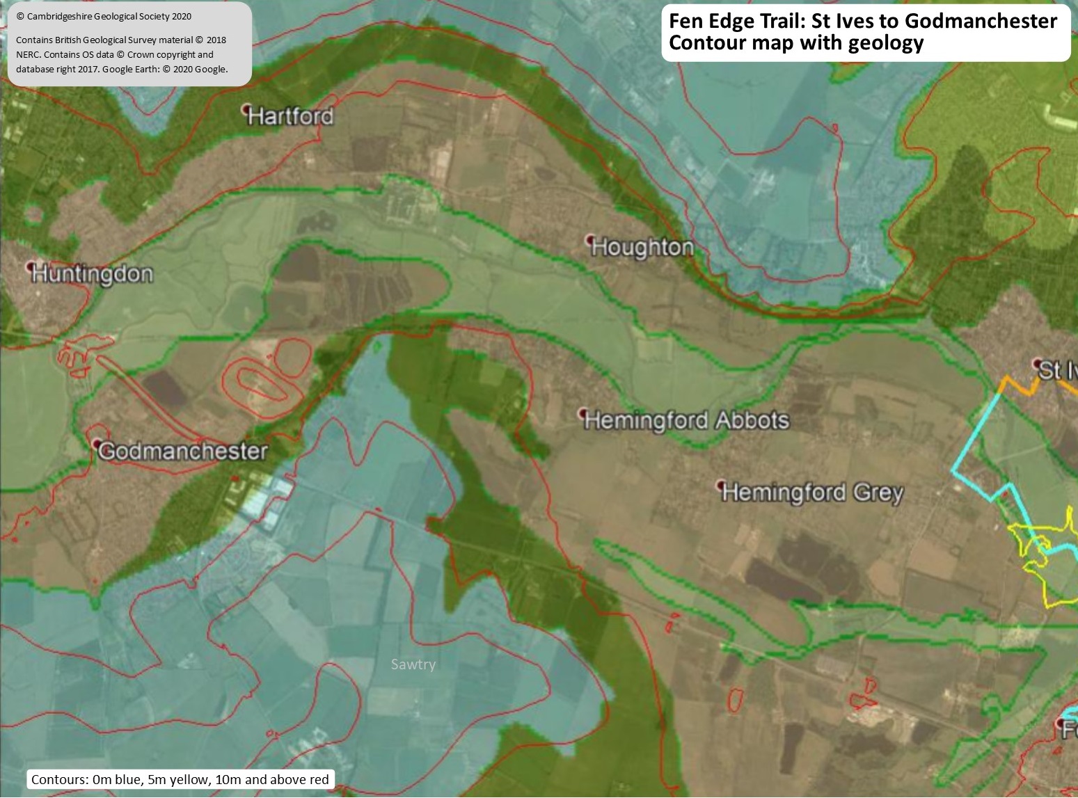
Walks 3 & 4 (14a & 14b): St Ives to Godmanchester via Houghton & return via the Hemingfords
Being planned
Although the main Trail then heads south to Fenstanton, an optional extension takes you further upstream through one of the most attractive sections of the river, via Houghton to Godmanchester and the extensive, and very biodiverse, Portholme Meadow. A short further walk takes you into the town of Huntingdon. The return walk takes you back along the south side of the river via the Wildlife Trust’s Godmanchester Nature Reserve and the Hemingfords.
")
")
© Cambridgeshire Geological Society